Autel Evo Max 4t Specs define a new era of drone technology for industrial and professional applications. CARDIAGTECH.NET provides an in-depth look at this powerful platform, highlighting its advanced capabilities and how it can revolutionize your operations. Discover enhanced productivity and cutting-edge features with the Autel EVO Max 4T specifications, offering a solution that meets the demands of various industries.
1. Unveiling the Autel EVO Max 4T: Advanced Features Overview
The Autel EVO Max 4T is not just another drone; it’s a sophisticated, autonomous platform designed for complex environments and demanding tasks. Its advanced features set it apart, making it an invaluable asset for professionals across various sectors. Let’s delve into what makes this drone a game-changer.
1.1. Autonomous Path Finding: Navigating Complex Terrains
The Autel EVO Max 4T’s Autonomy Engine is a standout feature, enabling it to collect environmental data and plan 3D flight paths in real-time. This capability is crucial for navigating complex environments such as mountains, forests, and urban landscapes.
Key Benefits:
- Rapid 3D Scene Reconstruction: Quickly generate detailed 3D models of environments.
- Enhanced Public Safety Overwatch: Provides comprehensive aerial surveillance for public safety operations.
- Efficient Industrial Inspection: Conduct thorough inspections of infrastructure and industrial sites.
- Accurate Land Surveying: Obtain precise data for land surveying and mapping projects.
1.2. GPS-Denied Navigation: Reliable Flight Indoors and Underground
One of the most impressive Autel EVO Max 4T specs is its ability to navigate in GPS-denied environments. Advanced sensors allow it to operate flawlessly within hardened structures, underground, or in areas where GPS signals are unavailable.
Key Benefits:
- Indoor Inspections: Perfect for inspecting indoor facilities like warehouses, factories, and tunnels.
- Underground Operations: Ideal for mining and infrastructure inspections where GPS is not accessible.
- Reliable Navigation: Ensures stable and accurate flight even without GPS signals.
1.3. Precise Object Identification and Tracking: AI-Powered Accuracy
Powered by Autel’s AI recognition technology, the EVO Max 4T can automatically identify and track different types of targets. This includes heat sources, moving people, and vehicles, enabling high-altitude tracking and data collection.
Key Benefits:
- Heat Source Detection: Identify and track heat signatures for search and rescue or industrial inspections.
- People Tracking: Monitor and track individuals for law enforcement or security purposes.
- Vehicle Tracking: Follow vehicles for surveillance or traffic monitoring.
- High-Altitude Data Collection: Gather data from a safe distance with pinpoint accuracy.
2. No Blind Spots: Unmatched Obstacle Avoidance System
The Autel EVO Max 4T sets a new standard in obstacle avoidance. By combining traditional binocular vision systems with millimeter-wave radar technology, it achieves unparalleled perception and safety.
2.1. Advanced Sensor Fusion: Seeing the Unseen
The EVO Max 4T is unique in the commercial drone market for integrating binocular vision and millimeter-wave radar. This fusion allows the onboard Autel Autonomy Engine to detect objects as small as 0.5 inches, effectively eliminating blind spots.
Key Advantages:
- Superior Detection: Detects obstacles of minimal size with high precision.
- Low-Light Performance: Operates reliably in low-light conditions where vision systems struggle.
- All-Weather Capability: Functions effectively in rainy conditions, ensuring uninterrupted operations.
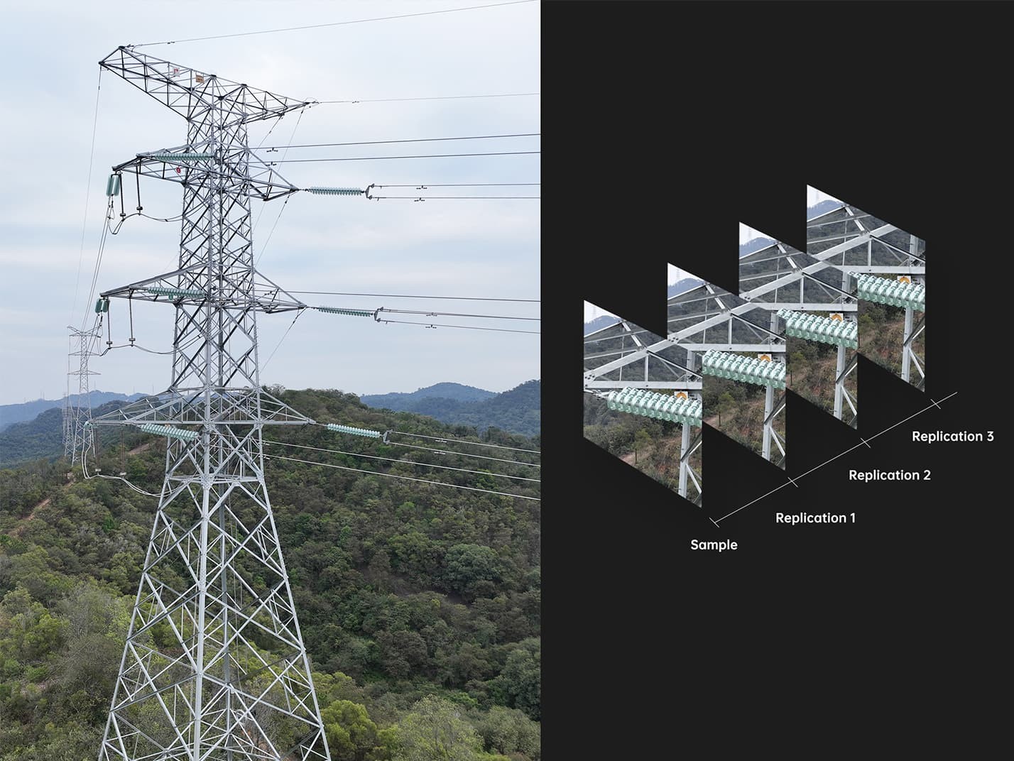
3. Anti-Jamming and Anti-Interference: Reliable Flight in Challenging Environments
The Autel EVO Max 4T is engineered to perform reliably in environments rife with interference. Advanced flight control modules and algorithms are specifically designed to counter RFI (Radio Frequency Interference), EMI (Electromagnetic Interference), and GPS spoofing.
3.1. Robust Design for Interference-Heavy Areas
The EVO Max 4T can confidently fly near power lines, critical structures, and in complex urban areas, thanks to its advanced interference mitigation technologies.
Key Benefits:
- RFI Mitigation: Reduces the impact of radio frequency interference on flight stability.
- EMI Resistance: Maintains stable operation in environments with high electromagnetic interference.
- GPS Spoofing Countermeasures: Protects against intentional GPS signal manipulation, ensuring accurate navigation.
4. Weather Rating: IP43 Certified
The Autel EVO Max 4T is designed to withstand harsh weather conditions. With an IP43 rating, it offers significant protection against water and dust, making it suitable for various outdoor applications.
4.1. Durable Construction for Outdoor Use
The IP43 rating signifies that the EVO Max 4T is protected against solid objects larger than 1mm and water spray from any direction.
Benefits of IP43 Rating:
- Dust Resistance: Prevents dust from entering and affecting internal components.
- Water Resistance: Can withstand water spray, making it suitable for use in light rain or damp conditions.
- Increased Longevity: Extends the lifespan of the drone by protecting it from environmental elements.
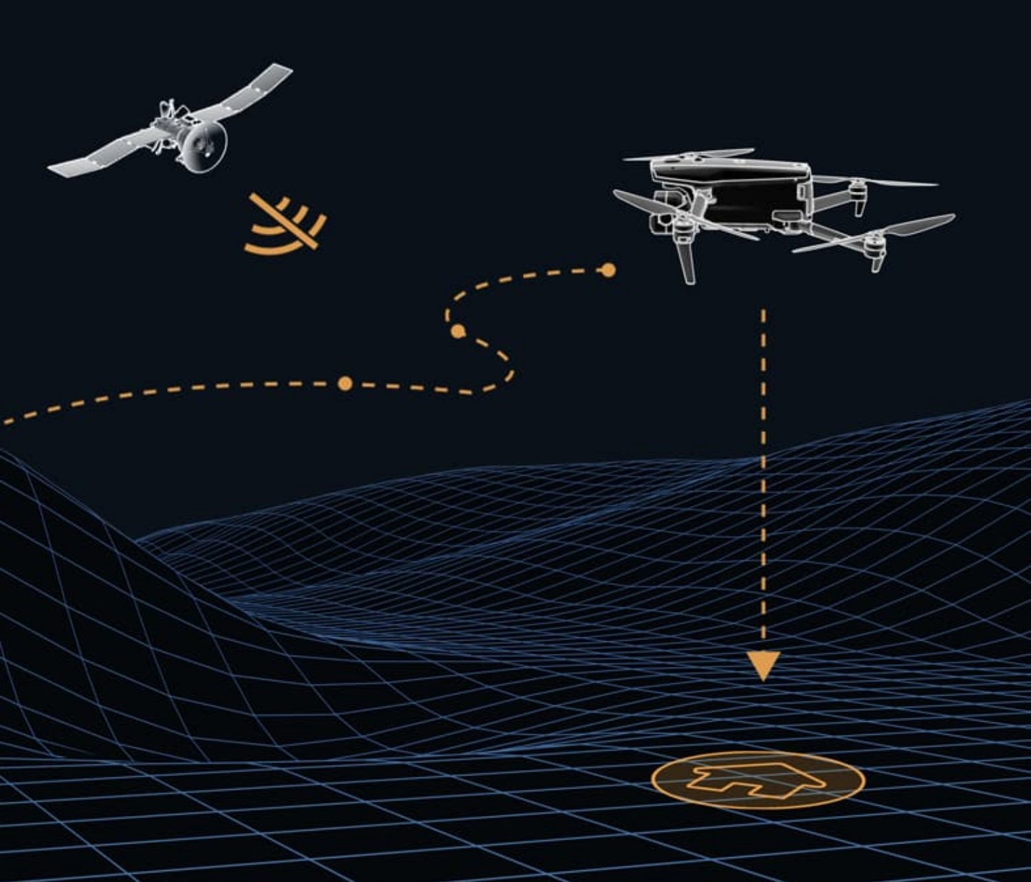
5. A-Mesh 1.0: Revolutionizing Drone Communication and Collaboration
The Autel EVO Max 4T introduces A-Mesh 1.0, the drone industry’s first mesh networking technology. This innovative system enables autonomous drone-to-drone communication, connection, and collaboration.
5.1. Decentralized Communication Network
Unlike traditional drone communication structures, A-Mesh allows the EVO Max 4T to communicate seamlessly with other drones in the vicinity. This decentralized approach ensures robust and reliable communication.
Key Advantages of A-Mesh 1.0:
- Strong Anti-Interference: If one drone fails, the system self-organizes and continues to relay critical information.
- Beyond-Line-of-Sight (BVLOS) Applications: Multiple aircraft can act as relay points, greatly improving BVLOS operation effectiveness.
- Full-Fleet Control: One pilot can autonomously control multiple drones, even without LTE coverage.
- Enhanced Range: Communication nodes can be placed on hills or poles or use a swarm of drones to extend coverage.
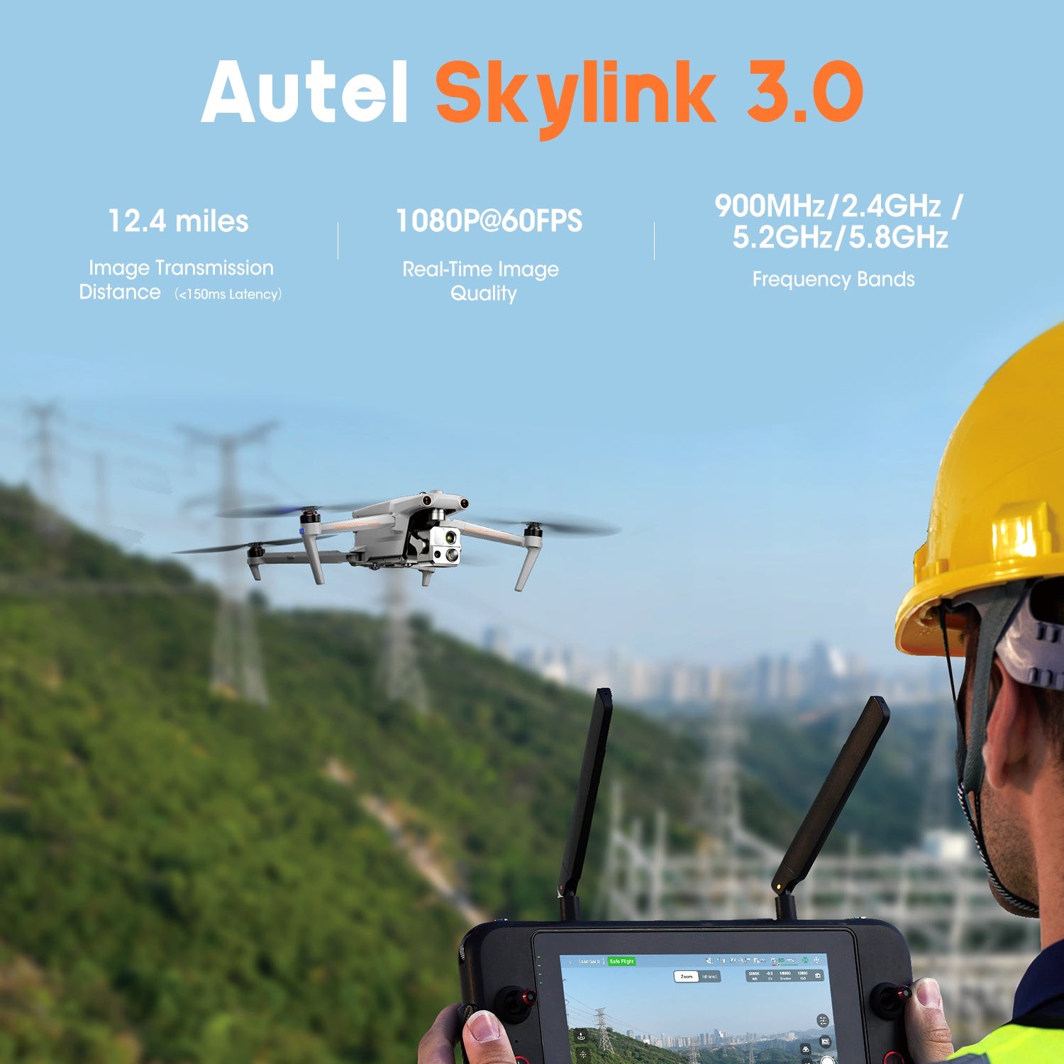
6. Autel SkyLink 3.0: Unparalleled Connectivity and Range
The Autel EVO Max 4T features the SkyLink 3.0 system, equipped with six antennas, four frequency bands, AES-256 encryption, and optional 4G integration. This provides users with the most advanced flight capabilities ever seen in an EVO drone.
6.1. Cutting-Edge Transmission Technology
SkyLink 3.0 ensures stable and reliable connectivity over long distances with high-quality real-time image transmission.
Key Features of SkyLink 3.0:
- Extended Range: Image transmission distance of up to 12.4 miles.
- High-Quality Video: Real-time image quality of 1080p/60fps.
- Multiple Frequency Bands: Operates on 900MHz, 2.4GHz, 5.2GHz, and 5.8GHz frequency bands.
- Enhanced Security: AES-256 encryption ensures secure data transmission.
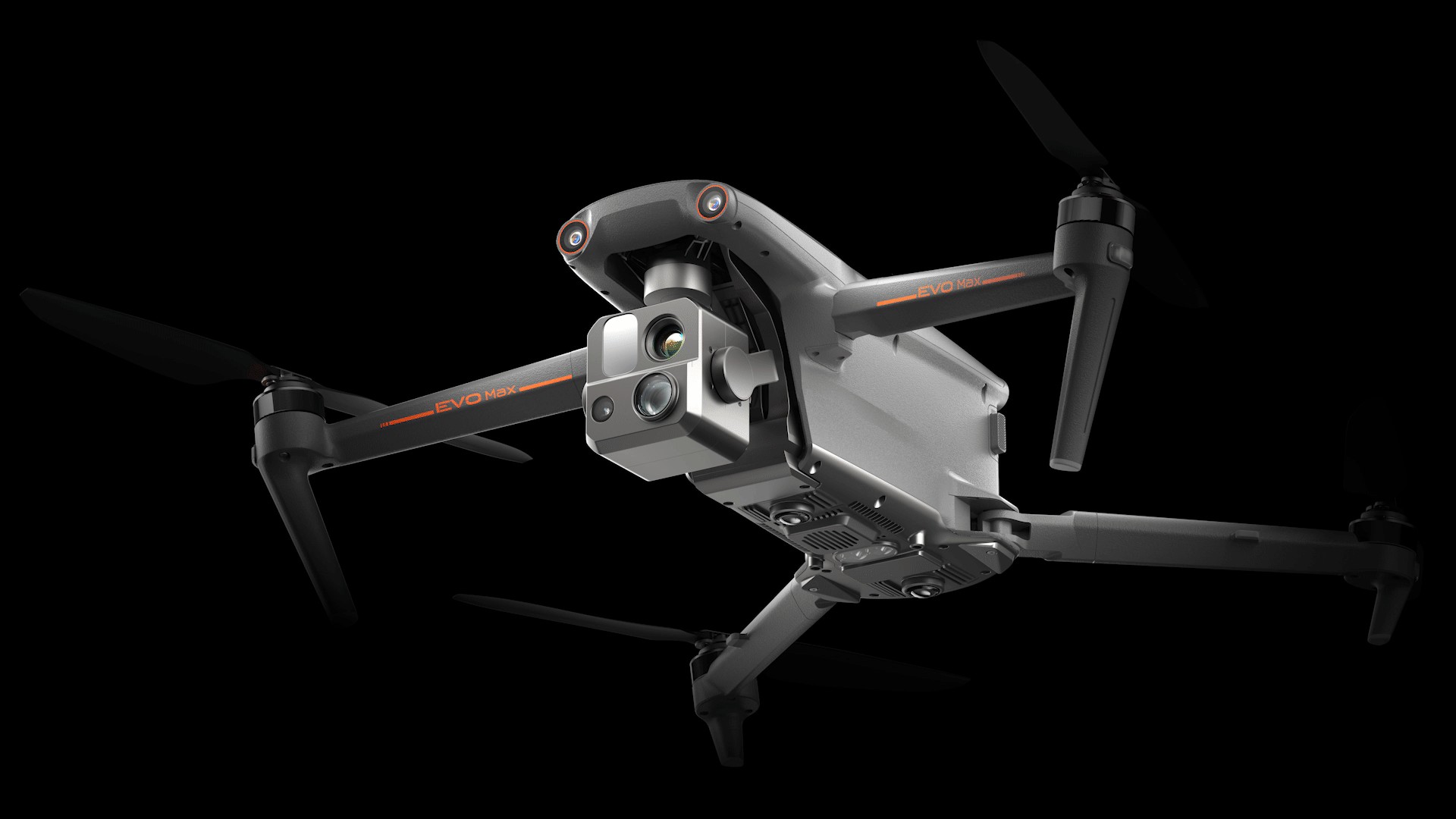
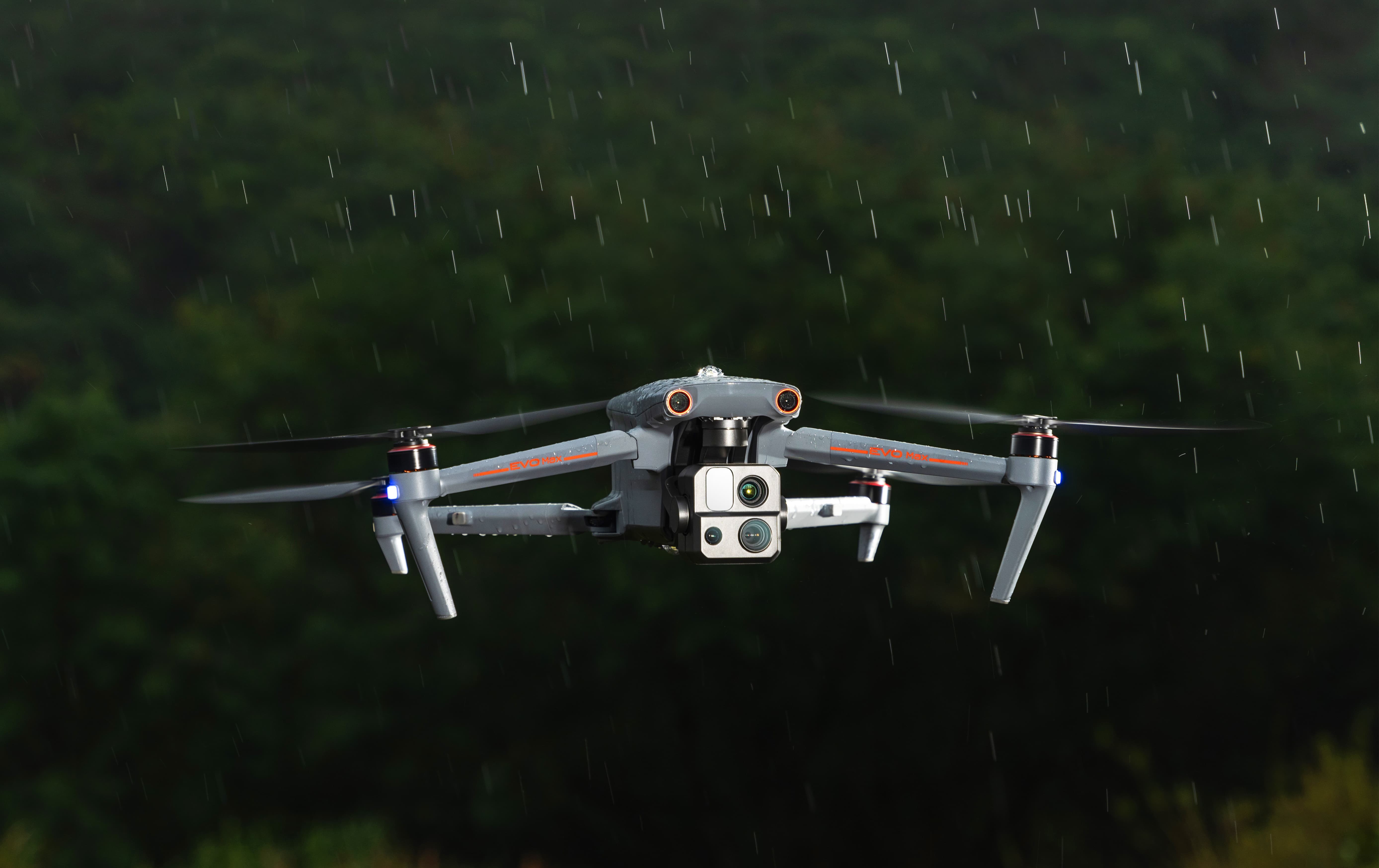
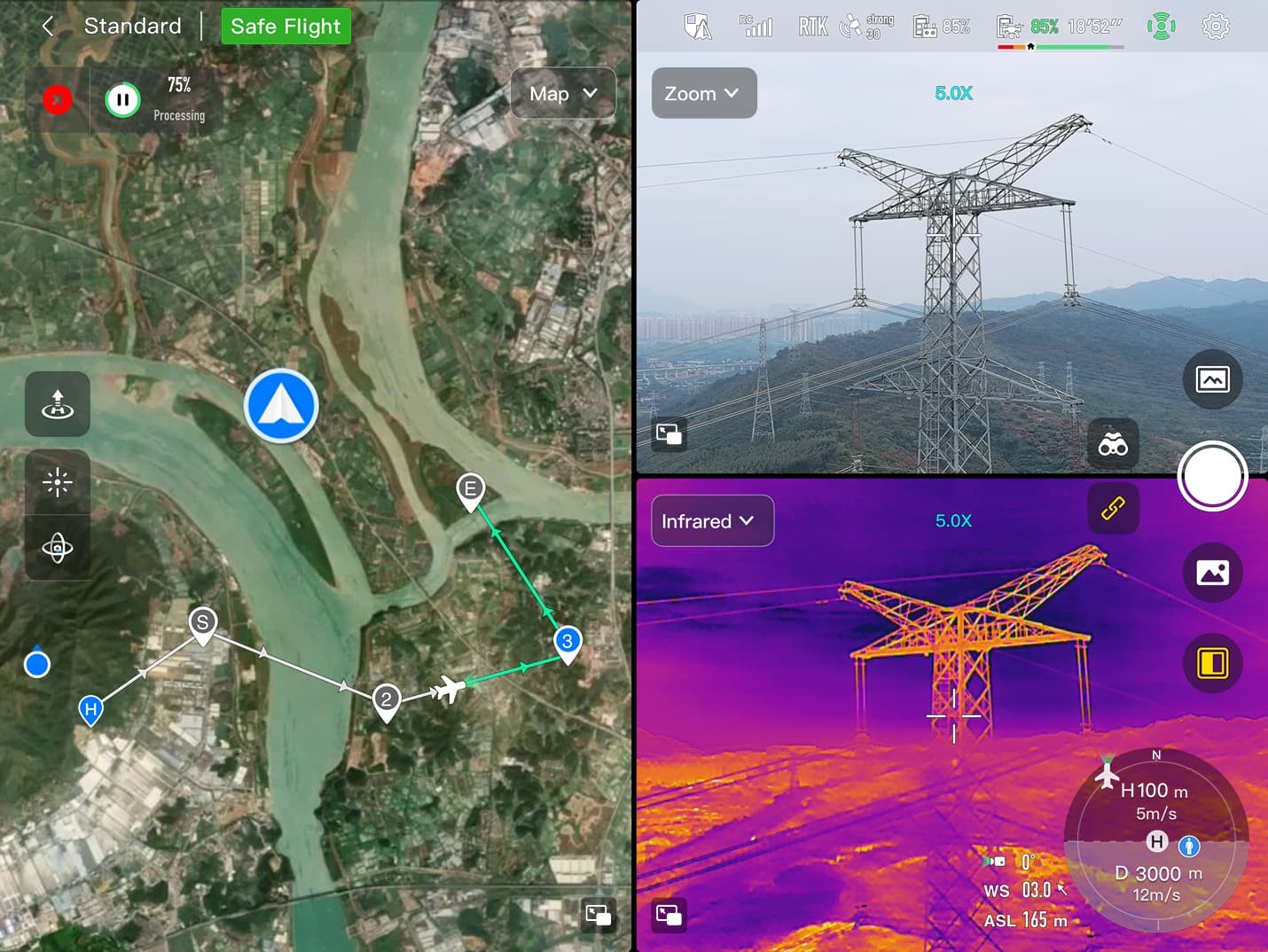
7. Mission-Ready Payload: Versatile Data Capture for Critical Decisions
The Autel EVO Max 4T comes with a versatile payload that integrates a wide-angle camera, zoom camera, thermal camera, and laser rangefinder. This combination allows for comprehensive data capture, crucial for making informed decisions.
7.1. Integrated Multi-Sensor System
The payload is designed to meet diverse data capture needs, from detailed visual inspections to thermal analysis and precise distance measurements.
Payload Components and Specifications:
| Component | Specification |
|---|---|
| Wide Camera | 48MP 1/2″ CMOS, f/2.8 Aperture, 83.4° DFOV |
| Zoom Camera | 48MP, 10x Optical Zoom, 160x Max. Hybrid Zoom, f/2.8-f/4.8 Aperture |
| Thermal Camera | 640×512, 9.1mm Aperture, 16x Digital Zoom, -20°C to 550°C Temperature Range |
| Laser Rangefinder | 5-1200m Measuring Range, +1m Measurement Accuracy |

Detailed Camera Specs:
- Wide Camera: Captures broad, high-resolution images with excellent detail. Its 48MP 1/2″ CMOS sensor ensures vibrant and clear visuals, perfect for mapping and situational awareness.
- Zoom Camera: Offers a 10x optical zoom and up to 160x hybrid zoom, allowing users to inspect distant objects without losing clarity. The f/2.8-f/4.8 aperture adapts to various lighting conditions.
- Thermal Camera: Equipped with a 640×512 resolution sensor, it detects temperature differences from -20°C to 550°C. This is ideal for search and rescue, firefighting, and industrial inspections.
- Laser Rangefinder: Measures distances between 5 and 1200 meters with an accuracy of +1 meter, essential for precise measurements and 3D modeling.
8. Autel Enterprise App Platform: Streamlined Operation and Advanced Features
The Autel Enterprise App is designed specifically for industrial applications, featuring a brand-new interface for simple and efficient operation. Additional features and semi-autonomous modes maximize the EVO Max 4T’s mission capabilities.
8.1. Intuitive Interface and Enhanced Functionality
The app provides a user-friendly experience while offering advanced controls and features to optimize drone operations.
Key Features of the Autel Enterprise App:
- Simple Interface: Streamlined design for easy navigation and operation.
- Efficient Operation: Optimized workflows for quick mission planning and execution.
- Semi-Autonomous Modes: Enhances mission capabilities with automated functions.
- Additional Features: Provides tools for data analysis, reporting, and mission management.
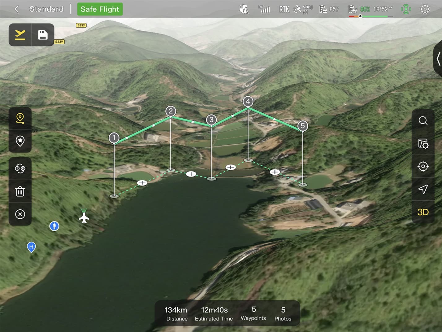
9. Smart Features: Intelligent Mission Planning and Execution
The Autel EVO Max 4T is equipped with smart features that simplify mission planning and execution, enhancing overall efficiency and data accuracy.
9.1. Streamlined Workflows for Complex Tasks
These smart features are designed to optimize various tasks, from 3D mapping to quick missions and mission reproduction.
Key Smart Features:
- 3D Map Planning: Plan, create, and execute 3D waypoint missions on a 3D map.
- Quick Mission: Create temporary quick missions while executing other missions, and stack multiple sub-missions for enhanced flexibility.
- Mission Reproduction: Automatically record camera angles and replicate missions for consistent data collection.
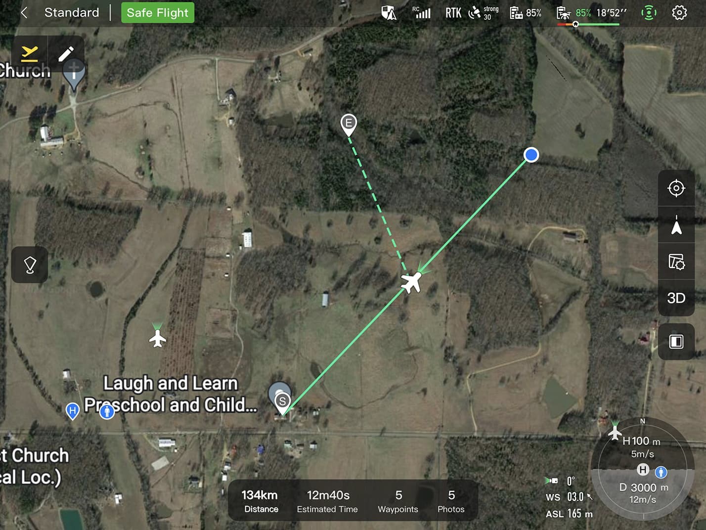
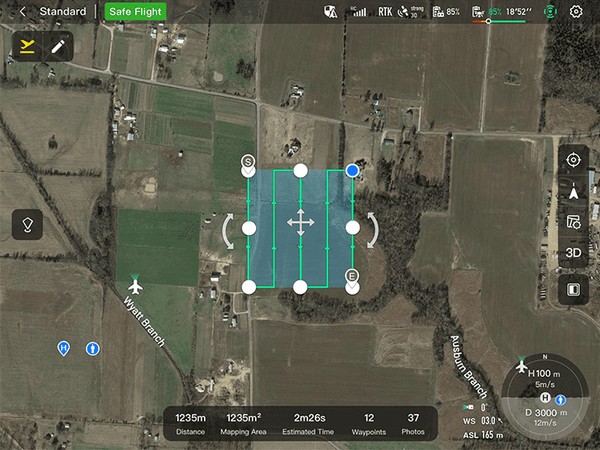
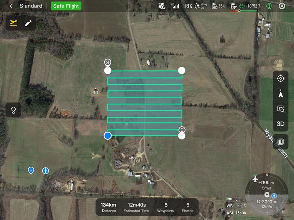
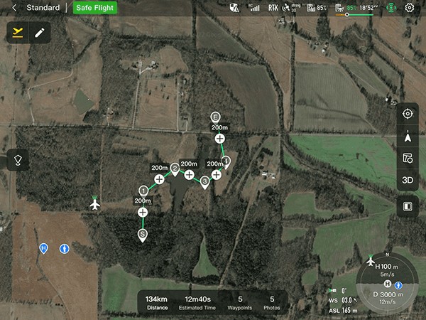
10. Multiple Mission Types: Versatile Planning for Diverse Applications
The Enterprise App provides various autonomous and semi-autonomous mission planning options, catering to public safety, inspection, and surveying needs.
10.1. Comprehensive Mission Planning Options
Whether you need to create a rectangular flight area, generate routes automatically, or set up custom waypoint missions, the EVO Max 4T offers the tools you need.
Available Mission Types:
- Rectangular Mission: One-click automatic generation of a rectangular flight area.
- Automatic Mission Generation and Data Capture: Automatically produce routes by adding regional boundary points or importing KML files.
- Waypoint Missions: Add waypoints for flexible, non-structured flight paths.
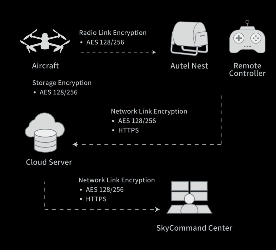
11. Data Security: Protecting Sensitive Information
Data security is a top priority with the Autel EVO Max 4T. Multiple layers of protection are in place to ensure that user and aircraft data remains secure.
11.1. Robust Security Measures
The EVO Max 4T employs advanced encryption and access controls to protect sensitive information.
Key Security Features:
- Privacy Protection: User and aircraft information can only be accessed physically via the aircraft locally.
- Encrypted Data Storage: Supports AES-256 encryption for photos, videos, and flight logs, with password protection.
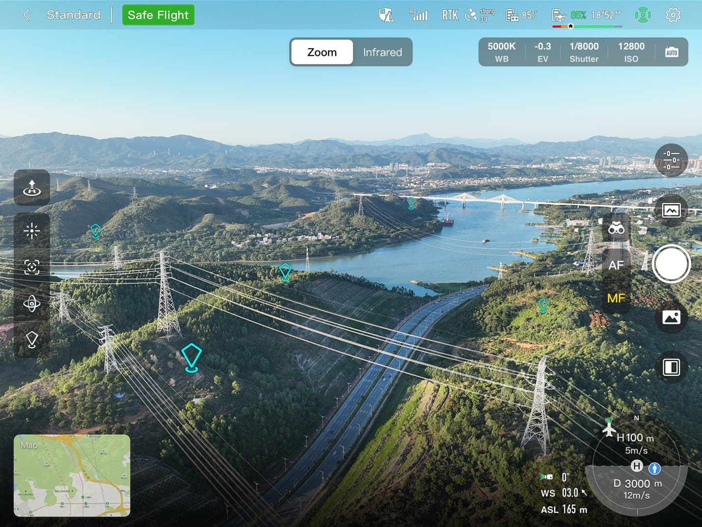
12. Enhanced Live-View: Real-Time Visual Data for Informed Decisions
The Autel EVO Max 4T’s enhanced live-view capabilities provide users with real-time visual data, allowing for informed decisions and improved situational awareness.
12.1. Advanced Display Options
The system supports multi-channel projection screens and AR scene overlays, enhancing the user’s ability to interpret and use visual data.
Key Live-View Enhancements:
- Multi-Channel Projection Screen: Supports simultaneous output of RGB, infrared, night vision, and wide-angle images.
- AR Scene: Geo-location data and other aircraft location info detected by ADS-B can overlay on a real-time map.
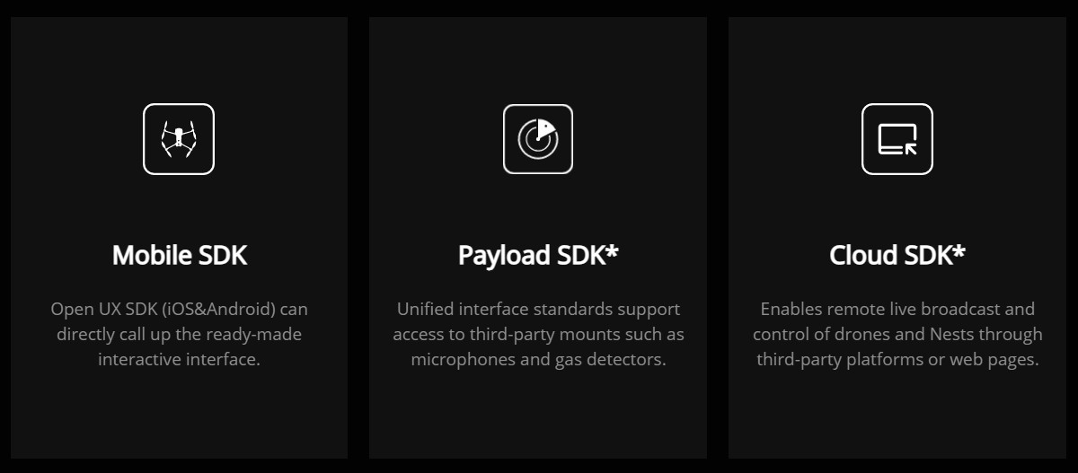
13. Autel SDK: Empowering Customization and Development
The Autel SDK opens up a world of possibilities for developers and partners, reducing software and hardware development costs and fostering a new industry ecosystem.
13.1. Open Platform for Innovation
The SDK allows for extensive customization and integration, enabling users to tailor the EVO Max 4T to their specific needs.
Benefits of the Autel SDK:
- Reduced Development Costs: Streamlines the development process, saving time and resources.
- Customization: Enables users to create custom applications and integrations.
- Innovation: Fosters a collaborative environment for innovation and development.
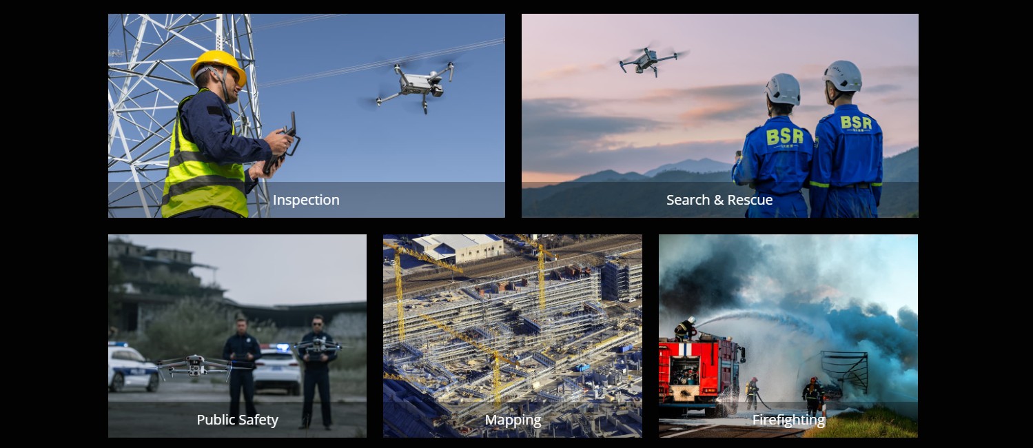
14. Widely Applicable: Versatile Solutions for Various Industries
The Autel EVO Max 4T is designed to meet the demands of various industries, providing versatile solutions for a wide range of applications.
14.1. Meeting Diverse Industry Needs
From infrastructure inspection to public safety and environmental monitoring, the EVO Max 4T is a valuable tool for professionals across sectors.
Key Applications:
- Infrastructure Inspection: Inspect bridges, power lines, and other critical infrastructure.
- Public Safety: Enhance search and rescue, law enforcement, and firefighting operations.
- Environmental Monitoring: Monitor wildlife, track pollution, and assess environmental impact.
- Agriculture: Optimize crop management with aerial imagery and data analysis.
- Construction: Monitor construction progress and create accurate site surveys.
15. Technical Specifications: A Deep Dive
To truly understand the capabilities of the Autel EVO Max 4T, let’s examine its comprehensive technical specifications. These Autel EVO Max 4T specs highlight the drone’s robust design, advanced features, and overall performance capabilities.
15.1. Aircraft Specifications
| Specification | Detail |
|---|---|
| Dimensions | |
| Folded | 476mm x 185mm x 198mm |
| Unfolded | 897mm x 780mm x 198mm |
| Wheelbase | 665 mm |
| Weight | |
| Takeoff Weight | 1.99 kg |
| Max Takeoff Weight | 2.3 kg |
| Max Payload | 750 g |
| Operating Temperature | -20°C to 50°C |
| Max Ascent Speed | 8 m/s (in sports mode) |
| Max Descent Speed | 6 m/s (in sports mode) |
| Max Horizontal Speed | 23 m/s (in sports mode, no wind) |
| Max Angular Rate | 120°/s |
| Max Flight Time | 42 minutes |
| Max Hovering Time | 38 minutes |
| Max Flight Distance | 38.5 km |
| Wind Resistance | 12 m/s |
| Max Altitude | 7000 m |
| GNSS | GPS, GLONASS, BeiDou, Galileo |
| Hovering Accuracy | Vertical: ±0.1 m (with vision system); ±0.5 m (with GPS) |
| Horizontal: ±0.3 m (with vision system); ±1.5 m (with GPS) | |
| Operating Frequency | 2.400-2.4835 GHz, 5.150-5.250 GHz, 5.725-5.850 GHz |
| Transmitter Power | 2.4 GHz: ≤33 dBm; 5.1 GHz: ≤23 dBm; 5.8 GHz: ≤33 dBm |
| Ingress Protection | IP43 |
15.2. Sensing System
| Feature | Detail |
|---|---|
| Type | Omnidirectional Obstacle Avoidance System |
| Forward | |
| Sensing Range | 1-80 m |
| FOV | Horizontal: 60°; Vertical: 80° |
| Backward | |
| Sensing Range | 1-32 m |
| FOV | Horizontal: 60°; Vertical: 80° |
| Left/Right | |
| Sensing Range | 1-32 m |
| FOV | Horizontal: 60°; Vertical: 80° |
| Upward | |
| Sensing Range | 0.5-30 m |
| FOV | 360° (Horizontal) |
| Downward | |
| Sensing Range | 0.5-18 m |
| FOV | Horizontal: 360° |
| Operating Environment | Surfaces with clear patterns and adequate lighting (>15 lux) |
| Millimeter Wave Radar | |
| Distance Range | 1-36 m |
| FOV | Horizontal: 90°; Vertical: 96° |
| Measurement Accuracy | 0.05 m |
15.3. Gimbal
| Specification | Detail |
|---|---|
| Number of Axes | 3-axis (pitch, roll, yaw) |
| Control Range | Pitch: -125° to +35°; Yaw: -90° to +90° |
| Max Control Speed | Pitch: 30°/s; Yaw: 30°/s |
| Angular Vibration Range | ±0.005° |
15.4. Wide-Angle Camera
| Specification | Detail |
|---|---|
| Sensor | 1/2″ CMOS; 48MP |
| Lens | FOV: 83.4°; Equivalent Focal Length: 24 mm; Aperture: f/2.8 |
| Focus Range | 1 m to ∞ |
| ISO Range | Video: 100-6400; Photo: 100-12800 |
| Max Resolution | 8000×6000 |
| Video Resolution | 3840×2160@30fps, 1920×1080@30fps |
| Digital Zoom | 1-8x |
| Photo Format | JPEG |
| Video Format | MP4 |
15.5. Zoom Camera
| Specification | Detail |
|---|---|
| Sensor | 1/2″ CMOS; 48MP |
| Lens | Optical Zoom: 10x; Aperture: f/2.8-f/4.8 |
| Digital Zoom | Max 160x Hybrid Zoom |
| Focus Range | 0.8 m to ∞ |
| ISO Range | Video: 100-6400; Photo: 100-12800 |
| Max Resolution | 8000×6000 |
| Video Resolution | 3840×2160@30fps, 1920×1080@30fps |
| Photo Format | JPEG |
| Video Format | MP4 |
15.6. Thermal Camera
| Specification | Detail |
|---|---|
| Thermal Imager | Uncooled VOx Microbolometer |
| Lens | Focal Length: 9.1 mm; Aperture: f/1.0 |
| Digital Zoom | 1-16x |
| IR Resolution | 640×512 |
| Pixel Pitch | 12 μm |
| NETD | ≤50 mK @ f/1.0 |
| Frame Rate | 30 Hz |
| Temperature Measurement Range | -20°C to 550°C |
| Temperature Measurement Accuracy | ±2°C or ±2% of reading (using the larger value) |
| Photo Format | JPEG |
| Video Format | MP4 |
15.7. Laser Rangefinder
| Specification | Detail |
|---|---|
| Wavelength | 905 nm |
| Measuring Range | 5-1200 m |
| Measurement Accuracy | ±1 m |
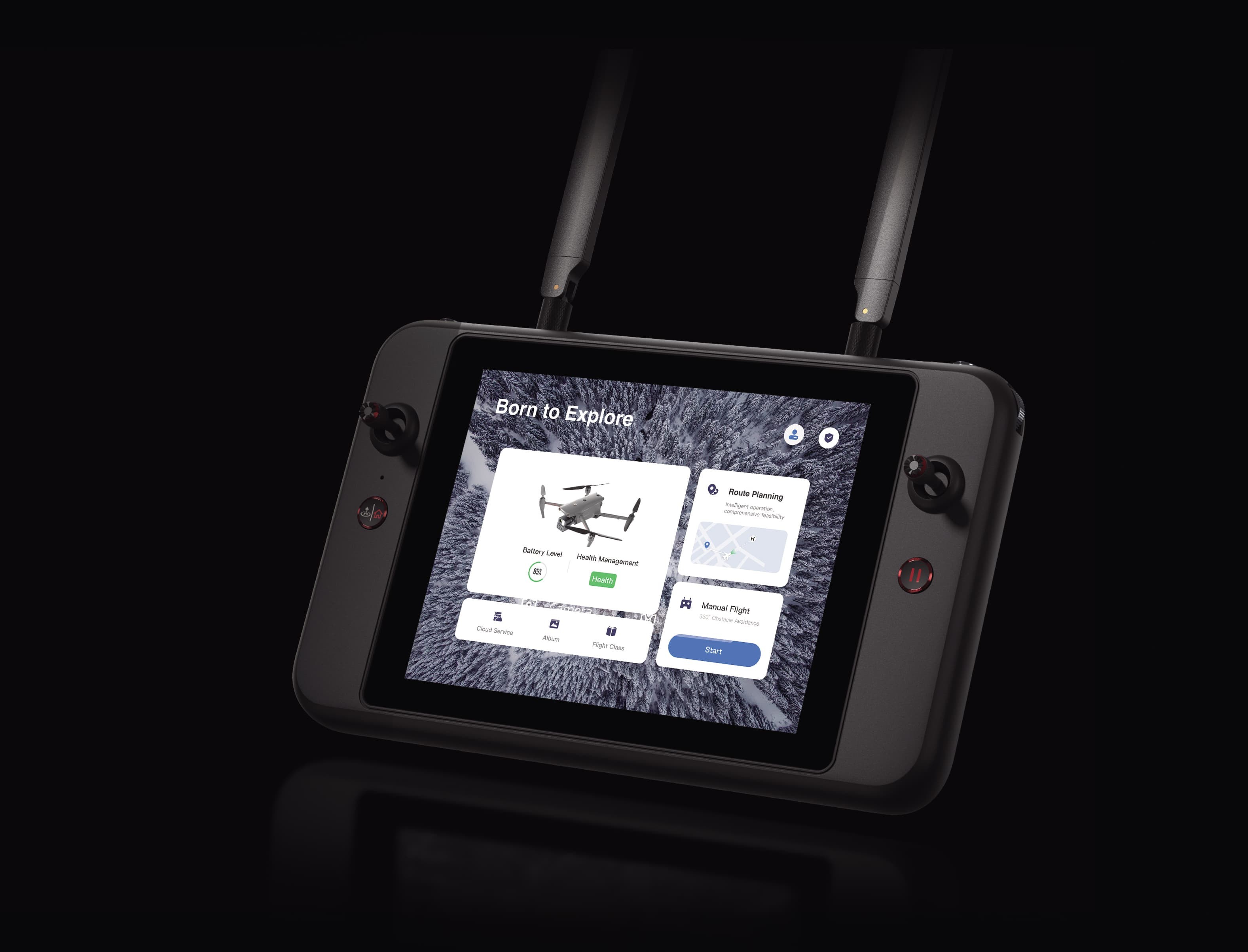
15.8. Remote Controller
| Specification | Detail |
|---|---|
| Operating Frequency | 2.400-2.4835 GHz, 5.150-5.250 GHz, 5.725-5.850 GHz |
| Transmitter Power | 2.4 GHz: ≤33 dBm; 5.1 GHz: ≤23 dBm; 5.8 GHz: ≤33 dBm |
| Max Transmission Distance | 15 km (FCC), 8 km (CE/SRRC/MIC) |
| Display Screen | 7.9 inches, 2048×1536, 1000 nit |
| Operating Temperature | -20°C to 45°C |
| Storage Temperature | -30°C to 60°C |
| Battery | Li-ion, 5800 mAh |
| Operating Time | 3 hours |
| Charging Time | 2 hours |
15.9. Battery
| Specification | Detail |
|---|---|
| Type | LiPo 4S |
| Capacity | 8920 mAh |
| Voltage | 15.4 V |
| Energy | 137.37 Wh |
| Weight | 550 g |
| Charging Temperature | 5°C to 45°C |
15.10. Storage
| Specification | Detail |
|---|---|
| Internal Storage | 128 GB |
| SD Card Support | Supports up to 256 GB MicroSD card |
16. Understanding User Intent: Five Key Search Intentions
When users search for “Autel EVO Max 4T specs,” they typically have one of five key intentions. Understanding these intentions allows us to provide content that directly addresses their needs.
- Detailed Specifications: Users want a comprehensive list of the drone’s technical specifications, including dimensions, weight, camera capabilities, and flight performance.
- Feature Overview: Users seek an overview of the drone’s key features, such as obstacle avoidance, thermal imaging, and autonomous flight modes.
- Comparison with Competitors: Users want to compare the EVO Max 4T with other drones in its class, assessing its strengths and weaknesses.
- Application Information: Users are interested in how the drone can be used in specific industries and applications, such as inspection, public safety, and surveying.
- Purchasing Information: Users are looking for information on where to buy the drone, including pricing, availability, and accessories.
17. FAQs: Your Questions About the Autel EVO Max 4T Answered
Here are some frequently asked questions about the Autel EVO Max 4T, designed to provide quick and informative answers.
- What is the flight time of the Autel EVO Max 4T? The Autel EVO Max 4T has a maximum flight time of up to 42 minutes.
- What is the range of the Autel EVO Max 4T? The Autel EVO Max 4T has a maximum transmission distance of up to 12.4 miles (20 km) under ideal conditions.
- Does the Autel EVO Max 4T have obstacle avoidance? Yes, the Autel EVO Max 4T features an omnidirectional obstacle avoidance system, combining binocular vision and millimeter-wave radar technology.
- What is the camera resolution of the Autel EVO Max 4T? The Autel EVO Max 4T is equipped with a 48MP wide-angle camera and a 48MP zoom camera.
- Does the Autel EVO Max 4T have a thermal camera? Yes, the Autel EVO Max 4T includes a thermal camera with a resolution of 640×512 and a temperature measurement range of -20°C to 550°C.
- What is the IP rating of the Autel EVO Max 4T? The Autel EVO Max 4T has an IP43 rating, meaning it is protected against solid objects larger than 1mm and water spray from any direction.
- What is A-Mesh 1.0? A-Mesh 1.0 is Autel’s mesh networking technology, enabling drone-to-drone communication, connection, and collaboration.
- What is the maximum wind resistance of the Autel EVO Max 4T? The Autel EVO Max 4T can withstand winds up to 12 m/s.
- What kind of missions can I plan with the Autel EVO Max 4T? The Autel EVO Max 4T supports rectangular missions, automatic mission generation, and waypoint missions.
- How secure is the data on the Autel EVO Max 4T? The Autel EVO Max 4T offers robust data security features, including AES-256 encryption for photos, videos, and flight logs, with password protection.
18. Maximizing Your Operations with CARDIAGTECH.NET
At CARDIAGTECH.NET, we understand the challenges faced by automotive repair professionals. From the physical demands of the job to the constant need for updated skills and tools, we’re here to provide solutions that enhance your efficiency, accuracy, and profitability.
18.1. Overcoming Your Challenges
- Physical Demands: Our tools are designed to be ergonomic and easy to use, reducing strain and fatigue.
- Constant Learning: We provide access to the latest information and training resources to keep you ahead of the curve.
- Time Pressure: Our efficient tools and equipment help you complete repairs quickly and accurately, minimizing downtime.
- Competition: By using our advanced tools, you can offer superior service and stand out from the competition.
- Finding the Right Tools: We offer a wide selection of high-quality tools and equipment to meet your specific needs.
18.2. How CARDIAGTECH.NET Helps
- Enhanced Efficiency: Our tools are designed to streamline your workflow and reduce repair times.
- Increased Accuracy: Precise tools ensure that repairs are done right the first time, reducing errors and rework.
- Cost Savings: By using high-quality tools, you can minimize the need for frequent replacements and reduce overall costs.
- Increased Revenue: With efficient and accurate repairs, you can serve more customers and increase your revenue.
- Improved Reputation: Providing high-quality service with advanced tools enhances your reputation and attracts more customers.
Ready to take your automotive repair business to the next level? Contact CARDIAGTECH.NET today to discover how our tools and equipment can transform your operations.
Contact Information:
- Address: 276 Reock St, City of Orange, NJ 07050, United States
- WhatsApp: +1 (641) 206-8880
- Website: CARDIAGTECH.NET
Let CARDIAGTECH.NET be your partner in success. We’re here to provide the tools and support you need to thrive in today’s competitive automotive repair industry. Act now and elevate your business with the best equipment available.